Robert M. Braley Jr. Photography

© Robert M. Braley Jr., Photographer


Home

links

Biography

Family Genealogy

Braley Genealogy

Eures Genealogy

Minimalism

United States

USAstatestable

Alaska

Alaska Highway

Milepost

Klondike Gold Rush

NWSR History

NWSR Aircraft

NWSR Other Uses

NWSR Airfields

Highway Proposals 1920s

Canol Pipeline 1942

Hwy Const Start 1942

Hwy Post War Trans 1946

Alaska Hwy Route Markings

Hwy Route Description

Hwy Bypassed Rd Segments

Alaska Hwy Today

Alaska Highway BC

Dawson Creek AH0000

Kaskatinaw River AH0021

Taylor AH0035

Fort St John AH0047

Charlie Lake AH0052

Beatton River AH0073

WonOWon AH0101

Pink Mountain AH0143

Suicide Hill AH0148

Buckinghorse River AH0175

Trutch Mt Summit AH0191

Adsett Creek AH0234

Fort Nelson AH0300

Tetsa River AH0375

Summit Lake 0392

Toad River AH0422

Muncho Lake AH0456

Liard Hot Springs AH0496

Smith River AH0514

Contact Creek AH0588

Teslin AH0604

BC Border AH 0627

Alaska Highway YT

Yukon Border AH0627

Watson Lake AH0635

Cassiar Hwy AW0649

Nugget City AH0650

Rancheria River AH0710

Cont Divide Lodge AH0721

Swift River AH0733

Johnsons Crossing AH0836

Marsh Lake AH0890

Whitehorse AH0905

Whitehorse AH0915

Canyon Creek AH0941

Pine Lake AH1010

Hanes Junction AH1016

Kllane Lake AH1067

Destruction Bay AH1083

Snag Junction AH1188

Burwash Landing AH1093

Beaver Creek AH1202

Alaska Highway AK

US Border AH1221

Border City AH1225

Tetlin AH1229

Deadman Lake AH1249

Deadman Lake CG AH1254

Lake View CG AH1257

Northway JCT AH1264

Taylor Hwy AH1306

Tok River AH1309

Tok Cutoff AH1314

Moon Lake AH1332

Delta Junction AH1422

Arkansas

Alma AR

Fort Smith AR

Van Buren AR

Charleston AR

Mulberry AR

Ozark AR

Altus AR

Clarksville AR

Russellville AR

Akins AR

Plumerville AR

Morriillton AR

Conway AR

Little Rock AR

Little Rock AFB AR

California

Bakersfield

Beverly Hills

Eureka CA

Fall River Mills

George AFB

Klamath AFS

Klamath WWII Radar

Los Angeles

Los Angeles West

Malibu

Samohi

Nautilus 1968

Nautilus 1967

Oxnard

Redwood NP

San Francisco

Santa Monica

Nautilus 1969

Venice

Whiskeytown

Colorado

Connecticut

Delaware

Florida

Georgia

Locust Grove GO

Warner Robbins AFB

Hawaii

Pearl Harbor

Kansas

Cherryvale KS

Coffeyville KS

Garnett KS

Ottawa KS

Kentucky

Idaho

Bosie

Idaho City

Mountain Home

Parma

Illinois

Indiana

Louisiana

Iowa

Maine

Maryland

Massachusetts

Michigan

Minnesota

Mississippi

Missouri

Montana

Nebraska

Gothenburg Neb

Nevada

New Hampshire

New Jersey

New York

New Mexico

Fort Stanton NM

Lincoln NM

Ruidoso

North Carolina

North Dakota

Ohio

Oklahoma

Adair OK

Arkansas River OK

Catoosa OK

Chouteau OK

Gore OK

Martin OK

Muskogee OK

Sallisaw OK

Tulsa OK

Wagoner OK

Warner OK

Webber Falls OK

Oregon

Ashland

Oregon Coast

Pennsylvania

Rhode Island

South Carolina

South Dakota

Tennessee

Athens TN

Knoxville TN

Texas

Utah

Vermont

Virginia

Washington

Anacortes WA

Centralia WA

Chehalis WA

Elbe WA

Fife WA

JBLM

Lewis County WA

Mt Rainer

Olympia WA

Port Angeles

Port Townsend

Seattle

Steilacoom WA

Tacoma

Tacoma TSA

Point Defiance Park

Washington D.C.

Wisconsin

West Virginia

Wyoming

Cheyenne WY

Creston WY

Evanston WY

Fort Bridger WY

Green River WY

Laramie WY

Medicine Bow WY

Pine Bluffs WY

Rock River WY

Table Rock, Wyoming

Walcott WY

Canada

British Columbia

70 Mile House BC

100 Mile House

108 Mile House

Hope BC

Stewart BC

Stewart Cassiar Hwy

Chetwynd

Clinton BC

Fraser River Valley

Hudsons Hope

Huston BC

Pouce Coupe BC

Dawson Creek VC

Dawson Creek DT

Yukon

Crete

Equator

Israel

Products

Nature

Animals

Flowers

Landscapes

Sunset

Wildflowers

Wildlife

Fish

Birds

Albatrosses

Canada Goose

Comorants

CaracarasFalcons

DucksGeeseSwans

Frigatebirds

Grebes

Loons

Osprey

PartridgesGrouse

Pelicans

redwingedblackbird1

HawksKitesEagles

ShearwatersPetrels

StormPetrels

Bats

Vultures

Mammals

Black Bear

bison

BitternsHeronsEgr

Caribou

Carnivorans

Cetaceans

Dall Sheep

Deer

Moose

Mountain Goat

Seals Sea Lions Walrus

Orca

Pikas Hares Rabbits

Polar Bear

Primates

Raccoons

Rodents

Great blue heron

Shrews

Bears

Beaver

Ungulates

Weasels

Military

Alaska Air National Guard

Kulis Air National Guard

Soldiers of the Mists pdf

Soldiers of the Mists

C-17

T-6G

T-33

P-51 Mustang

KC-135

HH-60

F-86

F-80

C-47

HC-130N

C-130H

C-130E

C-123J

Alaska National Guard

Camp Murray

Alaskanized

Ladd AFB

AKNG Museum

U-Tapao

The Salvation Army

Pixels

About

Policy/Copyright

Contact

Robert M Braley Jr

Family

Finance

Photo Sizes

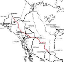
The Alaska Highway
Dawson Creek, British Columbia to Delta Junction, Alaska
(historical routes, heritage sites, sightseeing, driving tour)
Pioneer Road - Contract Road - Public Road

Whitehorse, Yukon Territory, Canada

Alaska Highway Sign
Alaska Highway Historic Mile 0

Historical Mile 905. Junction with South Klondike Highway to Skagway, AK

p2008061702417
   
The Klondike Highway is a highway that links the Alaskan coastal town of Skagway to Yukon's Dawson City. Its route somewhat parallels the route used by prospectors in the 1898 Klondike Gold Rush.

In Yukon, the Klondike Highway is marked as Yukon Highway 2. In Alaska, the Highway is marked as Alaska Route 98 (as in "route of 1898"). Until 1978, the unopened section between the BC border and Carcross had no official highway number, while the section north of Carcross to the Alaska Highway was Highway 5, and the section from Stewart Crossing to Dawson was Highway 3. The BC section is now maintained by the Yukon government as a natural extension of Highway 2.

History

The original 53 km (33 mi) section known locally as the Carcross Road was actually made into a part of the Alaska Highway in 1942, until the Marsh Lake route was opened the next year. As Yukon Highway 5, it formed a loop road with Highway 6, the Tagish Road (now numbered as 8). It was renumbered as Highway 2 in 1978, being incorporated into the Klondike Highway designation. The road underwent alignment improvements during the 1980s. Residents living as far south as 25 km (16 miles) from the Alaska Highway still give their residential addresses as historic mile measurements that start at zero at the Alaska Highway, even though the distances are no longer accurate, and kilometre posts count distance from Skagway's ferry terminal.

Construction of the "Carcross-Skagway Road" began in the 1950s, was abandoned partway up a mountain from Skagway, resumed in 1976-1977 and was completed between Skagway and Carcross in August 1978. It was only open for a few weeks before seasonal closure. The first full summer season of use was in 1979.

The highway originally was built for tourist traffic, but in 1986 became important as a commercial transportation route, coincident with what seemed to be inevitable abandonment of the White Pass and Yukon Route railway (WP&YR). The new owners of the Faro mine secured government agreement to open the highway for trucking. The last winter closure ended in the spring of 1986.

Historical Mile 906. Wolf Creek Yukon Government campground.

Wolf Creek Campground & Recreation Site (Yukon Gov't) is a provincial campground located in or near Whitehorse, YT.  The campground has 41 campsites.  The sites are all No Hookup sites.  Pull Thru sites are available at this campground.

It's all about comfort when it comes to a campground's utilities and amenities.  Do you like to rough it or 'rough it smoothly'?  Wolf Creek Campground & Recreation Site (Yukon Gov't) only offers No Hookup sites, a great choice if you like to rough it.  If your goal is to leave the rat race behind, then you can safely leave the TV and computer at home. Cable and Internet Access are not available at this campground.

Welcome to Yukon
© Robert M. Braley Jr. | Dreamstime.com


Become a image contributor at Dreamstime (as your stock photography agent) and start selling your camera and/or cell phone travel and other images. Learn how by clicking on a banner above.

Website powered by Network Solutions®