Become a image contributor at Dreamstime (as your stock photography agent) and start selling your camera and/or cell phone travel and other images. Learn how by clicking on a banner above.
Oregon is one of the most geographically diverse states in the U.S.,[7] marked by volcanoes, abundant bodies of water, dense evergreen and mixed forests, as well as high deserts and semi-arid shrublands. At 11,249 feet (3,429 m), Mount Hood, a stratovolcano, is the state's highest point. Oregon's only national park, Crater Lake National Park, comprises the caldera surrounding Crater Lake, the deepest lake in the United States. The state is also home to the single largest organism in the world, Armillaria ostoyae, a fungus that runs beneath 2,200 acres (8.9 km2) of the Malheur National Forest.[
Because of its diverse landscapes and waterways, Oregon's economy is largely powered by various forms of agriculture, fishing, and hydroelectric power. Oregon is also the top timber producer of the contiguous United States, and the timber industry dominated the state's economy in the 20th century.[9] Technology is another one of Oregon's major economic forces, beginning in the 1970s with the establishment of the Silicon Forest and the expansion of Tektronix and Intel. Sportswear company Nike, Inc., headquartered in Beaverton, is the state's largest public corporation with an annual revenue of $30.6 billion.[
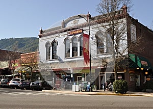
Ashland, Oregon
Oregon Coast
� Dreamstime.com
The city is the home of Southern Oregon University (SOU) and the Oregon Shakespeare Festival (OSF). These are important to Ashland's economy, which also depends on restaurants, galleries, and retail stores that cater to playgoers and other visitors. Lithia Park along Ashland Creek, historic buildings, and a paved intercity bike trail provide additional tourist attractions.
Ashland, originally called Ashland Mills, was named after Ashland County, Ohio, the original home of founder Abel Helman, and secondarily for Ashland, Kentucky, where other founders had family connections. Ashland has a mayor-council government assisted by citizen committees. Historically, its liberal politics have differed, often sharply, with much of the rest of southwest Oregon.
Ashlandis a city in Jackson County, in the State of Oregon. It lies along Interstate 5 slightly north of the California border and near the south end of the Bear Creek Valley, an arm of the Rogue Valley. As of July 1, 2013, the city's population was estimated to be 20,713.
� Dreamstime.com
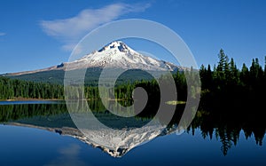
Mount Hood National Forest
The Mount Hood National Forest is located 62 miles (100 km) east of the city of Portland, Oregon, and the northern Willamette River valley. The Forest extends south from the Columbia River Gorge across more than 60 miles (97 km) of forestedmountains, lakes and streams to the Olallie Scenic Area, a high lake basin under the slopes of Mount Jefferson. The Forest includes and is named after Mount Hood, a stratovolcano.
� Dreamstime.com
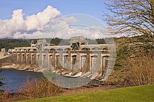
Bonneville Dam National Historic Landmark
Bonneville Lock and Dam consists of several run-of-the-riverdam structures that together complete a span of the Columbia River between the U.S. states of Oregon and Washington at River Mile 146.1. The dam is located 40 miles (64 km) east of Portland, Oregon, in the Columbia River Gorge. The primary functions of Bonneville Lock and Dam are electrical power generation and river navigation. The dam was built and is managed by the United States Army Corps of Engineers. Electrical power generated at Bonneville is distributed by the Bonneville Power Administration. Bonneville Lock and Dam is named for Army Capt. Benjamin Bonneville, an early explorer credited with charting much of the Oregon Trail. The Bonneville Dam Historic District was designated a National Historic Landmark District in 1987.
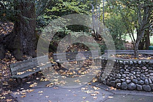
The park was listed on the National Register of Historic Places on November 22, 1982.
The area which now comprises the entrance to Lithia Park was the site of Abel Helman and Eber Emery's flour mill, the first building in what is now the city of Ashland—established in 1852. By the time the town (then called Ashland Mills) had grown up around the area, the old mill had become an eyesore, dirty with livestock and the mill all but abandoned.
"In 1883, a group of railroad surveyors headed by S. L. Dolson and David Loring arrived in Rock Point, near present day Gold Hill. They were charged with finding the best route through the Rogue Valley for the Oregon and California Railroad. Citizens of neighboring Jacksonville hoped that it would pass between their town and Hanley Butte, near the present day Claire Hanley Arboretum. Such a move would have all but guaranteed prosperous growth for Jacksonville, but Dolson decided instead to stake the railroad closer to Bear Creek. The response from Jacksonville was mixed, but the decision was final. By November 1883, a depot site had been chosen and a surveying team led by Charles J. Howard was hard at work platting the new town. They completed their work in early December 1883, laying out 82 blocks for development.
James Sullivan Howard, a New HampshireFreemason, claimed to have built the town's first building in January 1884, though blacksmith Emil Piel was advertising for business at the "central depot" in the middle of December. Others point out the farms of town founders Iradell Judson Phipps and Charles Wesley Broback, which were present before the town was platted. Regardless, on February 6, 1884 (less than a month after it was built), J. S. Howard's store became Medford's first post office, with Howard serving as postmaster. The establishment of the post office led to the incorporation of Medford as a town by the Oregon Legislative Assembly on February 24, 1885, and again as a city in 1905. Howard held the position of postmaster for Medford's first ten years, and again held the post upon his death on November 13, 1919." Source: Wikipedia
Medford is a city in Jackson County, Oregon, United States. As of July 1, 2013, the city had a total population of 77,677 and a metropolitan area population of 208,545, making the Medford MSA the 4th largest metro area in Oregon. The city was named in 1883 by David Loring, civil engineer and right-of-way agent for the Oregon and California Railroad for his home town of Medford, Massachusetts, and in recognition of its supposed position on the middle ford of Bear Creek.