Robert M. Braley Jr. Photography

© Robert M. Braley Jr., Photographer


Home

links

Biography

Family Genealogy

Braley Genealogy

Eures Genealogy

Minimalism

United States

USAstatestable

Alaska

Alaska Highway

Milepost

Klondike Gold Rush

NWSR History

NWSR Aircraft

NWSR Other Uses

NWSR Airfields

Highway Proposals 1920s

Canol Pipeline 1942

Hwy Const Start 1942

Hwy Post War Trans 1946

Alaska Hwy Route Markings

Hwy Route Description

Hwy Bypassed Rd Segments

Alaska Hwy Today

Alaska Highway BC

Dawson Creek AH0000

Kaskatinaw River AH0021

Taylor AH0035

Fort St John AH0047

Charlie Lake AH0052

Beatton River AH0073

WonOWon AH0101

Pink Mountain AH0143

Suicide Hill AH0148

Buckinghorse River AH0175

Trutch Mt Summit AH0191

Adsett Creek AH0234

Fort Nelson AH0300

Tetsa River AH0375

Summit Lake 0392

Toad River AH0422

Muncho Lake AH0456

Liard Hot Springs AH0496

Smith River AH0514

Contact Creek AH0588

Teslin AH0604

BC Border AH 0627

Alaska Highway YT

Yukon Border AH0627

Watson Lake AH0635

Cassiar Hwy AW0649

Nugget City AH0650

Rancheria River AH0710

Cont Divide Lodge AH0721

Swift River AH0733

Johnsons Crossing AH0836

Marsh Lake AH0890

Whitehorse AH0905

Whitehorse AH0915

Canyon Creek AH0941

Pine Lake AH1010

Hanes Junction AH1016

Kllane Lake AH1067

Destruction Bay AH1083

Snag Junction AH1188

Burwash Landing AH1093

Beaver Creek AH1202

Alaska Highway AK

US Border AH1221

Border City AH1225

Tetlin AH1229

Deadman Lake AH1249

Deadman Lake CG AH1254

Lake View CG AH1257

Northway JCT AH1264

Taylor Hwy AH1306

Tok River AH1309

Tok Cutoff AH1314

Moon Lake AH1332

Delta Junction AH1422

Arkansas

Alma AR

Fort Smith AR

Van Buren AR

Charleston AR

Mulberry AR

Ozark AR

Altus AR

Clarksville AR

Russellville AR

Akins AR

Plumerville AR

Morriillton AR

Conway AR

Little Rock AR

Little Rock AFB AR

California

Bakersfield

Beverly Hills

Eureka CA

Fall River Mills

George AFB

Klamath AFS

Klamath WWII Radar

Los Angeles

Los Angeles West

Malibu

Samohi

Nautilus 1968

Nautilus 1967

Oxnard

Redwood NP

San Francisco

Santa Monica

Nautilus 1969

Venice

Whiskeytown

Colorado

Connecticut

Delaware

Florida

Georgia

Locust Grove GO

Warner Robbins AFB

Hawaii

Pearl Harbor

Kansas

Cherryvale KS

Coffeyville KS

Garnett KS

Ottawa KS

Kentucky

Idaho

Bosie

Idaho City

Mountain Home

Parma

Illinois

Indiana

Louisiana

Iowa

Maine

Maryland

Massachusetts

Michigan

Minnesota

Mississippi

Missouri

Montana

Nebraska

Gothenburg Neb

Nevada

New Hampshire

New Jersey

New York

New Mexico

Fort Stanton NM

Lincoln NM

Ruidoso

North Carolina

North Dakota

Ohio

Oklahoma

Adair OK

Arkansas River OK

Catoosa OK

Chouteau OK

Gore OK

Martin OK

Muskogee OK

Sallisaw OK

Tulsa OK

Wagoner OK

Warner OK

Webber Falls OK

Oregon

Ashland

Oregon Coast

Pennsylvania

Rhode Island

South Carolina

South Dakota

Tennessee

Athens TN

Knoxville TN

Texas

Utah

Vermont

Virginia

Washington

Anacortes WA

Centralia WA

Chehalis WA

Elbe WA

Fife WA

JBLM

Lewis County WA

Mt Rainer

Olympia WA

Port Angeles

Port Townsend

Seattle

Steilacoom WA

Tacoma

Tacoma TSA

Point Defiance Park

Washington D.C.

Wisconsin

West Virginia

Wyoming

Cheyenne WY

Creston WY

Evanston WY

Fort Bridger WY

Green River WY

Laramie WY

Medicine Bow WY

Pine Bluffs WY

Rock River WY

Table Rock, Wyoming

Walcott WY

Canada

British Columbia

70 Mile House BC

100 Mile House

108 Mile House

Hope BC

Stewart BC

Stewart Cassiar Hwy

Chetwynd

Clinton BC

Fraser River Valley

Hudsons Hope

Huston BC

Pouce Coupe BC

Dawson Creek VC

Dawson Creek DT

Yukon

Crete

Equator

Israel

Products

Nature

Animals

Flowers

Landscapes

Sunset

Wildflowers

Wildlife

Fish

Birds

Albatrosses

Canada Goose

Comorants

CaracarasFalcons

DucksGeeseSwans

Frigatebirds

Grebes

Loons

Osprey

PartridgesGrouse

Pelicans

redwingedblackbird1

HawksKitesEagles

ShearwatersPetrels

StormPetrels

Bats

Vultures

Mammals

Black Bear

bison

BitternsHeronsEgr

Caribou

Carnivorans

Cetaceans

Dall Sheep

Deer

Moose

Mountain Goat

Seals Sea Lions Walrus

Orca

Pikas Hares Rabbits

Polar Bear

Primates

Raccoons

Rodents

Great blue heron

Shrews

Bears

Beaver

Ungulates

Weasels

Military

Alaska Air National Guard

Kulis Air National Guard

Soldiers of the Mists pdf

Soldiers of the Mists

C-17

T-6G

T-33

P-51 Mustang

KC-135

HH-60

F-86

F-80

C-47

HC-130N

C-130H

C-130E

C-123J

Alaska National Guard

Camp Murray

Alaskanized

Ladd AFB

AKNG Museum

U-Tapao

The Salvation Army

Pixels

About

Policy/Copyright

Contact

Robert M Braley Jr

Family

Finance

Photo Sizes

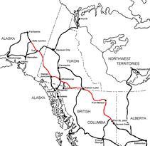
The Alaska Highway
Dawson Creek, British Columbia to Delta Junction, Alaska
(historical routes, heritage sites, sightseeing, driving tour)
Pioneer Road - Contract Road - Public Road


Alaska Highway Sign
© Robert M. Braley Jr. | Dreamstime.com

What lies in front of you now is a modern highway through a spectacular, mostly uninhabited land. But if you care to look, the ghosts of the old highway are everywhere. As part of the celebration of the 50th Anniversary of the highway in 1992, 40 interpretive panels were installed at historically significant points. The information that follows is largely reprinted from a 1992 brochure published jointly by the governments of B.C., the Yukon, and Alaska. For a look at the entire 1422-mile (2288.4 kilometer) highway in all seasons, have a look at our Alaska Highway Photo Album.

Pouce Coupe, British Columbia, Canada, www.poucecoupe.ca population 740, is 6 miles (10km) east of Dawson Creek – I spent a day in Pouce Coupe visiting the museum and viewing the vintage railway trestle.

All American men and equipment bound for Dawson Creek to build the ALCAN Highway would have crossed this trestle. The railroad trestle is still standing today, but is no longer in use. Pouce Coupe

The Alaska Highway begins at Mile 0 in Dawson Creek, BC. The first 613 miles/987 km of the Alaska Highway are in British Columbia, where it is designated BC Highway 97 North. The highway travels in a northwesterly direction to the Yukon Territory border near Watson Lake, YT (Historical Mile 635). From there it continues as Yukon Highway 1, crossing 577 miles/929 km of Yukon Territory to Port Alcan on the Alaska border. The Alaska Highway crosses into Alaska at Historical Mile 1221.8, where it becomes Alaska Route 2. From this international border, it is 200 miles/322 km to Delta Junction, AK (Historical Mile 1422), the official end of the Alaska Highway, and 298 miles to Fairbanks, the unofficial end of the highway, at Historical Mile 1520.

Road conditions on the Alaska Highway are not unlike road conditions on many secondary roads in the Lower 48. It is the tremendous length of the highway, combined with its remoteness and the extremes of the Northern climate, that often result in surprises along this highway. Historically speaking, however, the Alaska Highway has rarely been closed by any weather-related event, and even then usually not longer than a day.

Section 1 Dawson Creek - Fort Nelson  Section 2 Fort Nelson, BC - Watson Lake, YT Section 3 Watson Lake, YT - Delta Junction, Alaska

RCAF Station Dawson Creek

Dawson Creek, BC

Auxiliary refueling/servicing airfield. Historical Milepost 0

Historic Mile 0 Dawson Creek, BC the start of the Alaska Highway  www.tourismdawsoncreek.com Mile 0 Alaska Highway (ALCAN)

Historic Mile 2 Cantel Repeater Station: Cantel Telephone-teletype lines stretched from Alberta to Fairbanks, Alaska, making it one of the world's longest open wire toll circuits at the time.

Historic Mile 21 Kiskatinaw Bridge/Wallace A. MacKey Ltd: A 162-meter curved structure, one of the first of its kind in Canada, is the only original timber bridge built along the highway that is still in use today. This image was taken looking north from the south east corner of the bridge.

However, because of the weight limitations of this bridge the ALCAN Highway was rerouted to the west in 1979 and currently travelers cross a newer steel bridge. The guardrails were updated in summer 2014, after I took this image.

Historic Mile 35 Taylor and the Peace River Bridge/1st Main Army Camp 341st Engineers: Before the Peace was bridged in 1943, the ferry from Taylor served as the major link across the river. The original Peace River suspension bridge, the longest bridge on the highway, collapsed in 1957.  www.districtoftaylor.com

Historic Mile 47 Fort St. John/”Camp Alcan”: In 1942 Fort St John “exploded.” What had been home to 200 became temporary base for more than 6,000.  www.fortstjohn.ca

Fort St. John

Fort St. John, BC

Refueling/servicing airfield; 1459th AAFBU ATC Alaskan Division. Historic Milepost 47

Historic Mile 49 : Camp Alcan and the Public Roads Administration  Headquarters/Okes Management Contracting Headquarters – Standard Salt & Cement Company, Art Boiler, Sorenson & Volden, R.M. Smith Headquarters. As the southern sector headquarters for the United States Military and Public Roads Administration, Fort St John was the site of two large construction camps – pyramid tents and Quonset huts – erected in open fields just outside of town.

Historic Mile 52: Charlie Lake Mile 0 Army Tote Road. Site of a major distribution camp for workers and supplies heading north. Three American soldiers also drowned here in 1942 while crossing the lake abord “pontoon bargers.”


Historic Mile 72: The Shepherd’s Inn; popular food stop with gas, diesel, propane and lodging.

Historic Mile 73: Beatton River Flight Strip is one of the four gravel air strips constructed in northern British Columbia, Yukon and Alaska to provide emergency landing facilities for American military aircraft heading north.


Beatton River

Beatton River, BC

Emergency landing strip. Historic Milepost 73

Historic Mile 101: Blueberry Control Station (gate), a 24 – hour military checkpoint operated by U.S. Army personnel through the war years.


Historical Mile 143: PINK MOUNTAIN (pop. 99). Sunrise at Pink Mountain is spectacular and a must see and photograph.

Historic Mile 148 Suicide Hill is one of the most treacherous hills on the original highway noted for its ominous greeting: PREPARE TO MEET THY MAKER.

Sikanni Chief

Sikanni Chief River, BC

Emergency landing strip

Prophet River

Prophet River, BC

Emergency landing strip. Historic Milepost 233

Historic Mile 234 Adsett Creek Highway Realignment: Completed in 1992, this major rerouting eliminated 132 curves on the stretch of highway that originally ran between Miles 234 and 275.

Historical Mile 300. Fort Nelson, BC  is a friendly town founded during the fir trade. Fort Nelson Museum showcases the construction of the Alaska Highway. Between Fort Nelson and Muncho Lake look for Stones Sheep, American Bison and other wildlife.

Fort Nelson

Fort Nelson, BC

Was main refueling/servicing point on route; 1460th AAFBU ATC Alaskan Division. Remained as joint RCAF/USAF base until about 1949; hosted Det.2, 1701st Air Transport Wing (MATS) Historic Milepost 300

Historical Mile 375. Tetsa River

Historic Milepost 392, Summit Lake; no services. Summit Pass (elev. 4,250 feet/1,295m), highest summit on the Alaska Highway. Summit Lake (Stone Mountain) Provincial Campground. The campground here is dry camp only with back-in rv spots not to exceed 30' in length. There is a large parking lot across the highway where larger vehicles can park overnight.

At 4,250 feet, this is the highest summit on the highway. At Mile 397, crews had to blast through the rock to create a road. This is Stone Mountain and there will be anywhere between 1 and 100 Stone Sheep on the clifts above and below. There is only one pull-out at the cliff. Everytime I pass this point, I get several new images of Stone Sheep.

Historic Mile 422 Toad River/Camp 138 Jupp Construction: The community was established by Dennis and John Callison who, upon leading Public Roads Administration surveyors into the area in the winter of 1941, saw opportunities there and staked their claim.

Historic Mile 456: Muncho Lake/ Refuling Stop and Checkpoint - The road around the lake was a particular challenge. Workers had to cut their way through the lake's rocky banks and use horse-pulled stone boats to haul the rock away. This is the only lodge open year round between Fort Nelson and Watson Lake.

Historical Mile 496: Liard River Hotsprings Provincial Park; camping. Stop at the Liard River Hot Springs Provincial Park and bath in the natural pools.

Smith River

Smith River, BC

Emergency landing strip. Closed in 1970. Historic Milepost 514

Historic Milepost 588, Contact Creek.

Historical Mile 590: Contact Creek Lodge

Yukon Territory, Canada

Historic Milepost 627: marks official British Columbia–Yukon Territory border.

Historic Milepost 635, Watson Lake (pop. 1,563); all services. Junction of the Alaska and the Campbell highways. Attractions: Watson Lake Signpost Forest and view over 67,900 license plates, road shields and homemade signs, Northern Lights Centre.

Watson Lake/Liard River

Watson Lake, YT

Refueling/servicing airfield; 1461st AAFBU ATC Alaskan Division. Historic Milepost 635

Cousins

Whitehorse, YT

Emergency landing strip. Still in use today.

Historic Mile 649, junction with the Cassiar Highway. They have a very nice RV park here with full hook-up.

Even though I did not manage to get a photograph of it, this is the location where I spotted the largest Bull Moose I have ever seen. I must have weighed somewhere around 2000 lbs and had about an 8 foot rack. It lives on protected land owned by Junction 37 Services and no hunting is allowed. Even the local First Nation will not shoot it as it is to big and to old.

Historic Mile 650 Nugget City.

Historic Mile 710 R Ranchara: Rancheria Lodge

Historic Mile 721. Continental Divide Lodge.

Historic Mile 733, SWIFT RIVER. Swift River Lodge.

Pine Lake

Swift River, YT

Emergency landing strip. Historic Milepost 733

Historic Mile 797 Nsultin Bay Bridge, longest water span on the Alaska Highway.

Telsin

Historic Mile 804, Telsin

Teslin Lake

Teslin Lake, YT

Emergency landing strip still in use today. Historic Milepost 804

Historic Mile 836, Johnson's Crossing

Squanga Lake

Johnsons Crossing, YT

Emergency landing strip. Historical Milepost 836

Historic Mile 890. Marsh Lake Yukon government campground. Army Beach.

Whitehorse, Yukon

Historic Mile 905. Junction with South Klondike Highway to Skagway, AK

Historic Mile 906. Wolf Creek Yukon Government campground.

Historic Mile 911. Pioneer RV Park

Historic Mile 915: Attraction: Yukon Beringia Interpretive Center.

RCAF Station Whitehorse

Whitehorse, YT

Refueling/servicing airfield; 1462d AAFBU ATC Alaskan Division; also known as Whitehorse Army Air Base. Remained as joint RCAF/USAF base until about 1949; hosted Det.3, 1701st Air Transport Wing (MATS).

Historic Mile 922: Car and Truck Stop.

Historic Mile 941.

Champagne

Champagne, YT

Emergency landing strip, constructed 1941 by Canadian government. Historic Milepost 968

Pine Lake

Pine Lake, YT

Auxiliary refueling/servicing airfield, constructed 1941 by Canadian government.

Silver City

Silver City, YT

Emergency landing strip, constructed 1941 by Canadian government. - Historical Milepost 1053

Hanes Junction, Yukon

Historic Mile 1016, junction with Haines Highway to Haines, AK, at community of Hanes Junction (pop. 840)

Our Lady of the Way Catholic Mission (1943)

Silver City

Silver City, YT

Emergency landing strip, constructed 1941 by Canadian government. - Historical Milepost 1053

Large turnout on Kluane Lake, largest lake in Yukon Territory.

Historic Mile 1067.

Historic Mile 1072. Congdon Creek Yukon government campground.

Destruction Bay, Yukon

Historic Mile 1083, Destruction Bay

Historic Mile 1093, Burwash Landing (pop. 84)

Burwash Landing

Burwash Landing, YT

Emergency landing strip, constructed 1941 by Canadian government.

Historic Mile 1152. Lake Creek Yukon government campground.

Historic Mile 1164. Cook’s Koidern River Lodge (closed in 2011)

Historic Mile 1188. Snag Junction Yukon government campground.

Snag

Snag, YT

Abandoned. Emergency landing strip, constructed 1941 by Canadian government.

Beaver Creek, Yukon

Historic Mile 1202, BEAVER CREEK (pop. 112)

Visitors Center: In 2013 I was invited by a local First Nation Individual to tour his private Alaska Highway Museum. He has a collection of over 1000 artifactes from the construction of the highway. He gathered many items as they took them apart and discarded them in the trash. The only true all highway artifact museum on the highway.

DC 1168.5 Canadian Customs Beaver Creek station.

Alaska, USA

Historic Mile 1221.8 U.S. Customs border station Port Alcan.

Historic Mile 1225.5 Boder City

Historic Mile 1229 Tetlin National Wildlife Refuge Visitor Center.

Historic Mile 1254. Deadman Lake (Tetlin NWR) Campground.

Northway, AK

Historic Mile 1264 Northway Junction

Northway Army Airfield

Northway, AK

Refueling/servicing airfield; 1463d AAFBU ATC Alaskan Division.

Tanacross Air Base

Tanacross, AK

Refueling/servicing airfield; 1464th AAFBU ATC Alaskan Division.

Historic Mile 1306 Tetlin Junction. Junction with the Taylor Highway, which leads to Eagle and to Top of the World Highway to Dawson City, Yukon.

Historic Mile 1314.2 Junction of Alaska Highway and Tok Cutoff at TOK (pop. 1,435)

Historic Mile 1422 Junction of the Alaska and Richardson highways at DELTA JUNCTION (pop. 984);

Big Delta Army Airfield

Delta Junction, AK

Refueling/servicing airfield; 1464th AAFBU ATC Alaskan Division.

Mile 26 Field

Fairbanks, AK

Axillary for Ladd AAB

Ladd Army Airfield

Fairbanks, AK

Was main transfer point for Lend-Lease aircraft from United States ATC pilots to Soviet Red Air Force pilots; aircraft then flown to Siberia after transfer.

The Alaska-Siberia (Ak-Sib) Fly Route

Galena Airport

Galena, AK

Refueling/servicing airfield; 1468th AAFBU ATC Alaskan Division.

Marks Army Airfield

Nome, AK

Final servicing point for aircraft; 1469th AAFBU ATC Alaskan Division.

Gambell Army Airfield

Gambell, AK

Final refueling stop prior to aircraft being flown into Soviet airspace. Ref.

Advertisment Links to Dreamstime My RF Stock Agent Profile

Website powered by Network Solutions®