Robert M. Braley Jr. Photography

© Robert M. Braley Jr., Photographer


Home

links

Biography

Family Genealogy

Braley Genealogy

Eures Genealogy

Minimalism

United States

USAstatestable

Alaska

Alaska Highway

Milepost

Klondike Gold Rush

NWSR History

NWSR Aircraft

NWSR Other Uses

NWSR Airfields

Highway Proposals 1920s

Canol Pipeline 1942

Hwy Const Start 1942

Hwy Post War Trans 1946

Alaska Hwy Route Markings

Hwy Route Description

Hwy Bypassed Rd Segments

Alaska Hwy Today

Alaska Highway BC

Dawson Creek AH0000

Kaskatinaw River AH0021

Taylor AH0035

Fort St John AH0047

Charlie Lake AH0052

Beatton River AH0073

WonOWon AH0101

Pink Mountain AH0143

Suicide Hill AH0148

Buckinghorse River AH0175

Trutch Mt Summit AH0191

Adsett Creek AH0234

Fort Nelson AH0300

Tetsa River AH0375

Summit Lake 0392

Toad River AH0422

Muncho Lake AH0456

Liard Hot Springs AH0496

Smith River AH0514

Contact Creek AH0588

Teslin AH0604

BC Border AH 0627

Alaska Highway YT

Yukon Border AH0627

Watson Lake AH0635

Cassiar Hwy AW0649

Nugget City AH0650

Rancheria River AH0710

Cont Divide Lodge AH0721

Swift River AH0733

Johnsons Crossing AH0836

Marsh Lake AH0890

Whitehorse AH0905

Whitehorse AH0915

Canyon Creek AH0941

Pine Lake AH1010

Hanes Junction AH1016

Kllane Lake AH1067

Destruction Bay AH1083

Snag Junction AH1188

Burwash Landing AH1093

Beaver Creek AH1202

Alaska Highway AK

US Border AH1221

Border City AH1225

Tetlin AH1229

Deadman Lake AH1249

Deadman Lake CG AH1254

Lake View CG AH1257

Northway JCT AH1264

Taylor Hwy AH1306

Tok River AH1309

Tok Cutoff AH1314

Moon Lake AH1332

Delta Junction AH1422

Arkansas

Alma AR

Fort Smith AR

Van Buren AR

Charleston AR

Mulberry AR

Ozark AR

Altus AR

Clarksville AR

Russellville AR

Akins AR

Plumerville AR

Morriillton AR

Conway AR

Little Rock AR

Little Rock AFB AR

California

Bakersfield

Beverly Hills

Eureka CA

Fall River Mills

George AFB

Klamath AFS

Klamath WWII Radar

Los Angeles

Los Angeles West

Malibu

Samohi

Nautilus 1968

Nautilus 1967

Oxnard

Redwood NP

San Francisco

Santa Monica

Nautilus 1969

Venice

Whiskeytown

Colorado

Connecticut

Delaware

Florida

Georgia

Locust Grove GO

Warner Robbins AFB

Hawaii

Pearl Harbor

Kansas

Cherryvale KS

Coffeyville KS

Garnett KS

Ottawa KS

Kentucky

Idaho

Bosie

Idaho City

Mountain Home

Parma

Illinois

Indiana

Louisiana

Iowa

Maine

Maryland

Massachusetts

Michigan

Minnesota

Mississippi

Missouri

Montana

Nebraska

Gothenburg Neb

Nevada

New Hampshire

New Jersey

New York

New Mexico

Fort Stanton NM

Lincoln NM

Ruidoso

North Carolina

North Dakota

Ohio

Oklahoma

Adair OK

Arkansas River OK

Catoosa OK

Chouteau OK

Gore OK

Martin OK

Muskogee OK

Sallisaw OK

Tulsa OK

Wagoner OK

Warner OK

Webber Falls OK

Oregon

Ashland

Oregon Coast

Pennsylvania

Rhode Island

South Carolina

South Dakota

Tennessee

Athens TN

Knoxville TN

Texas

Utah

Vermont

Virginia

Washington

Anacortes WA

Centralia WA

Chehalis WA

Elbe WA

Fife WA

JBLM

Lewis County WA

Mt Rainer

Olympia WA

Port Angeles

Port Townsend

Seattle

Steilacoom WA

Tacoma

Tacoma TSA

Point Defiance Park

Washington D.C.

Wisconsin

West Virginia

Wyoming

Cheyenne WY

Creston WY

Evanston WY

Fort Bridger WY

Green River WY

Laramie WY

Medicine Bow WY

Pine Bluffs WY

Rock River WY

Table Rock, Wyoming

Walcott WY

Canada

British Columbia

70 Mile House BC

100 Mile House

108 Mile House

Hope BC

Stewart BC

Stewart Cassiar Hwy

Chetwynd

Clinton BC

Fraser River Valley

Hudsons Hope

Huston BC

Pouce Coupe BC

Dawson Creek VC

Dawson Creek DT

Yukon

Crete

Equator

Israel

Products

Nature

Animals

Flowers

Landscapes

Sunset

Wildflowers

Wildlife

Fish

Birds

Albatrosses

Canada Goose

Comorants

CaracarasFalcons

DucksGeeseSwans

Frigatebirds

Grebes

Loons

Osprey

PartridgesGrouse

Pelicans

redwingedblackbird1

HawksKitesEagles

ShearwatersPetrels

StormPetrels

Bats

Vultures

Mammals

Black Bear

bison

BitternsHeronsEgr

Caribou

Carnivorans

Cetaceans

Dall Sheep

Deer

Moose

Mountain Goat

Seals Sea Lions Walrus

Orca

Pikas Hares Rabbits

Polar Bear

Primates

Raccoons

Rodents

Great blue heron

Shrews

Bears

Beaver

Ungulates

Weasels

Military

Alaska Air National Guard

Kulis Air National Guard

Soldiers of the Mists pdf

Soldiers of the Mists

C-17

T-6G

T-33

P-51 Mustang

KC-135

HH-60

F-86

F-80

C-47

HC-130N

C-130H

C-130E

C-123J

Alaska National Guard

Camp Murray

Alaskanized

Ladd AFB

AKNG Museum

U-Tapao

The Salvation Army

Pixels

About

Policy/Copyright

Contact

Robert M Braley Jr

Family

Finance

Photo Sizes

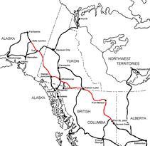
The Alaska Highway
Dawson Creek, British Columbia to Delta Junction, Alaska
(historical routes, heritage sites, sightseeing, driving tour)
Pioneer Road - Contract Road - Public Road


Independence Mine Alaska
© Robert M. Braley Jr. | Dreamstime.com

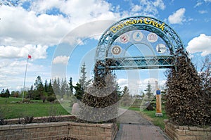
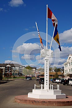
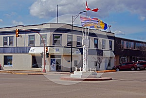
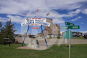
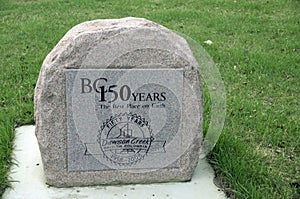
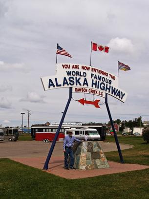
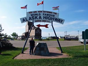
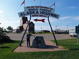
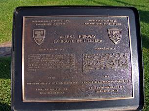
Historic Mile 0, Dawson Creek, British Columbia, Canada 
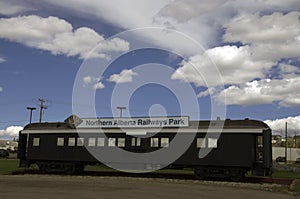
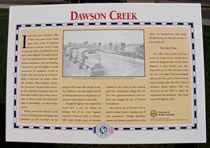
Dawson Creek is a city in northeastern British Columbia, Canada. The municipality of 24.37 square kilometres (9.41 sq mi) had a population of 11,583 in 2011. Dawson Creek derives its name from the creek of the same name that runs through the community. The creek was named after George Mercer Dawson by a member of his land survey team when they passed through the area in August 1879. Once a small farming community, Dawson Creek became a regional centre when the western terminus of the Northern Alberta Railways was extended there in 1932. The community grew rapidly in 1942 as the US Army used the rail terminus as a transshipment point during construction of the Alaska Highway. In the 1950s, the city was connected to the interior of British Columbia via a highway and railway through the Rocky Mountains. Since the 1960s, growth has slowed.
The city is named after George Mercer Dawson (as is Dawson City, Yukon): a 19th century railroad surveyor, geologist and anthropologist who was one of the very first white men to travel through the area.

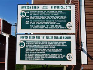
Dawson Creek is named after the watercourse of the same name, itself named after who led a surveying team through the area in August 1879; a member of the team labelled the creek with Dawson's name. The community that formed by the creek was one of many farming communities established by European-Canadian settlers moving west through the Peace River Country. When the Canadian government began issuing homestead grants to settlers in 1912, the pace of migration increased. With the opening of a few stores and hotels in 1919 and the incorporation of the Dawson Creek Co-operative Union on 28 May 1921, Dawson Creek became a dominant business centre in the area. After much speculation by land owners and investors, the Northern Alberta Railways built its western terminus 3 km (2 mi) from Dawson Creek. The golden spike was driven on 29 December 1930, and the first passenger train arrived on 15 January 1931. The arrival of the railway and the construction of grain elevators attracted more settlers and business to the settlement. The need to provide services for the rapidly growing community led Dawson Creek to incorporate as a village in May 1936. A small wave of refugees from the Sudetenland settled in the area in 1939 as World War II was beginning. The community exceeded 500 people in 1941.

In 1942 the USA and Canada united for a cause. After the Japanese attack on Pearl Harbor, fear paralyzed North America. FDR, concerned about an invasion of Alaska, dusted off a decades old idea to build a road to the Alaskan interior. Ref.

Upon entering the war, the United States decided to build a transportation corridor to connect the US mainland to Alaska. In 1942, thousands of US Army personnel, engineers, and contractors poured into the city – the terminal of rail transport – to construct the Alaska Highway. The highway was completed in less than a year; even after the workers involved in its construction departed, population and economic growth continued. In February 1943, a major fire and explosion in a livery barn, packed with road-building supplies including dynamite, caused serious damage to the center of town; five people were killed and 150 injured.
In the spring of 1942, "the End Of Steel" became a major terminus for troops, supplies, and equipment arriving from Edmondton and destined for the north.

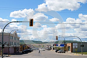
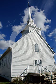
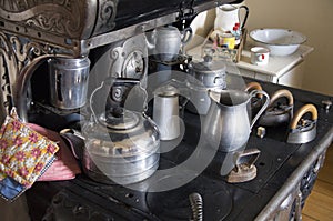
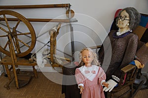
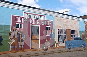
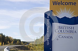
Dawson Creek is located in the dry and windy prairie land of the Peace River Country. As the seat of the Peace River Regional District and a service centre for the rural areas south of the Peace River, the city has been called the "Capital of the Peace". It is also known as the "Mile 0 City", referring to its location at the southern end of the Alaska Highway. It also has a heritage interpretation village, an art gallery, and a museum. Annual events include a fall fair and rodeo. Start of the Alaska Highway Visitor Centre
By 1951, Dawson Creek had more than 3,500 residents. In 1952, the John Hart Highway linked the town to the rest of the British Columbia Interior and Lower Mainland through the Rocky Mountains; a new southbound route, known locally as Tupper Highway, made the town a crossroads with neighbouring Alberta. The next year, western Canada's largest propane gas plant was built and federal government offices were established in town. In 1958, the extension of the Pacific Great Eastern Railway to the Peace from Prince George was completed, and the village was re-incorporated as a city. Between 1951 and 1961, the population of Dawson Creek more than tripled.

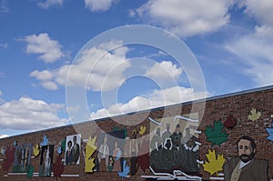
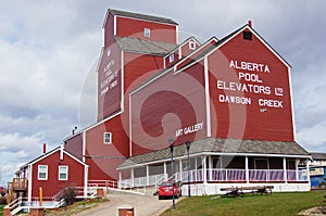
Growth slowed in the 1960s, with the population reaching its all-time high in 1966. In the 1970s, the provincial government moved its regional offices from Pouce Coupe to the city, Northern Lights College opened a Dawson Creek campus, and the Dawson Creek Mall was constructed. Several modern grain elevators were built, and the town's five wooden grain elevators, nicknamed "Elevator Row", were taken out of service. Only one of the historic elevators remains, converted to an art gallery. Since the 1970s, with the nearby town of Fort St. John attracting much of the area's industrial development and Grande Prairie becoming a commercial hub, the town's population and economy have not significantly increased.

Since 1992, the city has undergone several boundary expansions. One expansion incorporated undeveloped land in the southeast for an industrial park and a Louisiana-Pacific Canada veneer factory. The city extended sewer and water lines to the location; however, the area was not developed and with the factory only half-built, L-P Canada abandoned its plans. A business making manufactured homes bought the factory and completed its development in 2005. Another expansion incorporated the existing oriented strand board factory in the northwest corner of the city, while further incorporations have included undeveloped land to the south and north.

Black-Capped Chickadee Small bird in tree
© Robert M. Braley Jr.
Dawson Creek, British Columbia

Black-Capped Chickadee Small bird in tree
© Robert M. Braley Jr.
Palmer, Alaska

Black-Capped Chickadee Small bird in tree
© Robert M. Braley Jr.
Dawson Creek, British Columbia

Black-Capped Chickadee Small bird in tree
© Robert M. Braley Jr.
Dawson Creek, British Columbia

Black-Capped Chickadee Small bird in tree
© Robert M. Braley Jr.
Dawson Creek, British Columbia

Black-Capped Chickadee Small bird in tree
© Robert M. Braley Jr.
Dawson Creek, British Columbia

Black-Capped Chickadee Small bird in tree
© Robert M. Braley Jr.
Dawson Creek, British Columbia

Black-Capped Chickadee Small bird in tree
© Robert M. Braley Jr.
Dawson Creek, British Columbia

Black-Capped Chickadee Small bird in tree
© Robert M. Braley Jr.
Dawson Creek, Yukon

Black-Capped Chickadee Small bird in tree
© Robert M. Braley Jr.
Tacoma, Washington

Black-Capped Chickadee Small bird in tree
© Robert M. Braley Jr.
Dawson Creek, British Columbia

Black-Capped Chickadee Small bird in tree
© Robert M. Braley Jr.
Dawson Creek, British Columbia

Black-Capped Chickadee Small bird in tree
© Robert M. Braley Jr.
Dawson Creek, British Columbia

Black-Capped Chickadee Small bird in tree
© Robert M. Braley Jr.
Dawson Creek, British Columbia

Black-Capped Chickadee Small bird in tree
© Robert M. Braley Jr.
Dawson Creek, British Columbia

Black-Capped Chickadee Small bird in tree
© Robert M. Braley Jr.
Dawson Creek, British Columbia

Black-Capped Chickadee Small bird in tree
© Robert M. Braley Jr.
Dawson Creek, British Columbia

Black-Capped Chickadee Small bird in tree
© Robert M. Braley Jr.
Dawson Creek, British Columbia

Black-Capped Chickadee Small bird in tree
© Robert M. Braley Jr.

Welcome to British Columbia
© Robert M. Braley Jr.
Welcome to British Columbia


Black-Capped Chickadee Small bird in tree
© Robert M. Braley Jr.
Dawson Creek, British Columbia

Black-Capped Chickadee Small bird in tree
© Robert M. Braley Jr.
British Columbia

Black-Capped Chickadee Small bird in tree
© Robert M. Braley Jr.
British Columbia

Black-Capped Chickadee Small bird in tree
© Robert M. Braley Jr.
Dawson Creek, British Columbia

Welcome to British Columbia
© Robert M. Braley Jr.
Dawson Creek, British Columbia

Black-Capped Chickadee Small bird in tree
© Robert M. Braley Jr.
Dawson Creek, British Columbia

Black-Capped Chickadee Small bird in tree
© Robert M. Braley Jr.
Dawson Creek, Yukon

Black-Capped Chickadee Small bird in tree
© Robert M. Braley Jr.

Mt. Rainer Washington<
© Robert M. Braley Jr.

Black-Capped Chickadee Small bird in tree
© Robert M. Braley Jr.

Black-Capped Chickadee Small bird in tree
© Robert M. Braley Jr.

Black-Capped Chickadee Small bird in tree
© Robert M. Braley Jr.

Black-Capped Chickadee Small bird in tree
© Robert M. Braley Jr.

Black-Capped Chickadee Small bird in tree
© Robert M. Braley Jr.
Dawson Creek, British Columbia

Black-Capped Chickadee Small bird in tree
© Robert M. Braley Jr.
Dawson Creek, British Columbia

Black-Capped Chickadee Small bird in tree
© Robert M. Braley Jr.
British Columbia

Black-Capped Chickadee Small bird in tree
© Robert M. Braley Jr.
Dawson Creek, British Columbia

Alaska Highway Sign
© Robert M. Braley Jr. | Dreamstime.com

Vintage Alaska Highway Sign
© Robert M. Braley Jr. | Dreamstime.com

Historic Mile 0 Dawson Creek, British Columbia/start of the Alaska Highway, Dawson Creek Flight Strip, Public Roads Administration, R. Melville Smith Camp, U.S. Engineers Camp, M.H.K.C.B. Construction Company Camp, Area No 1 & 2 Army Camp, Dowell Construction Company Camp, U.S.Q.M.C, Headquarters Alaska Highway.

Alaska Highway
© Robert M. Braley Jr. | Dreamstime.com


Alaska Highway
© Robert M. Braley Jr. | Dreamstime.com

Alaska Highway
© Robert M. Braley Jr. | Dreamstime.com

Alaska Highway
© Robert M. Braley Jr. | Dreamstime.com

Alaska Highway
© Robert M. Braley Jr. | Dreamstime.com


Alaska Highway
© Robert M. Braley Jr. | Dreamstime.com

Alaska Highway Stone Mountain Sheep
© Robert M. Braley Jr. | Dreamstime.com

Alaska Highway Stone Mountain Sheep
© Robert M. Braley Jr. | Dreamstime.com

Alaska Highway Stone Mountain Sheep
© Robert M. Braley Jr. | Dreamstime.com

Alaska Highway Stone Mountain Sheep
© Robert M. Braley Jr. | Dreamstime.com

p2008061602338
p2008061602341
p2008061602339

Palm Tree
© Robert M. Braley Jr. | Dreamstime.com

p2008053102256
p2008053102257

Alaska Highway Vintage Mill
© Robert M. Braley Jr. | Dreamstime.com

Alaska Highway Train Station
© Robert M. Braley Jr. | Dreamstime.com

p2008053102258
p2008053102260
p2008053102251
p2008053102252
p2008053102253
p2008053102259
p2008053102254
p2008053102255
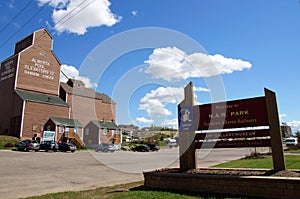
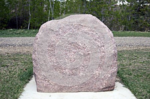
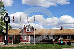
Northern Alberta Railways Park in the heart of the city hosts the Visitor Centre, the Railway Station Museum, a northern wildlife display, the local art gallery, the Mile 0 Cairn, 2 gift shops, public washrooms and plenty of large vehicle parking.
                     

Black-Capped Chickadee Small bird in tree
© Robert M. Braley Jr. | Dreamstime.com

Black-Capped Chickadee Small bird in tree
© Robert M. Braley Jr. | Dreamstime.com


Alaska Highway
© Robert M. Braley Jr. | Dreamstime.com

Black-Capped Chickadee Small bird in tree
© Robert M. Braley Jr. | Dreamstime.com

Black-Capped Chickadee Small bird in tree
© Robert M. Braley Jr. | Dreamstime.com

Vintage Kitchen Alaska Highway
© Robert M. Braley Jr. | Dreamstime.com

Vintage Childrens Bedroom Alaska Highway
© Robert M. Braley Jr. | Dreamstime.com

Vintage Kitchen WWII Alaska Highway
© Robert M. Braley Jr. | Dreamstime.com

Vintage Kitchen Stove Alaska Highway
© Robert M. Braley Jr. | Dreamstime.com

Vintage Sewing WWII Alaska Highway
© Robert M. Braley Jr. | Dreamstime.com

Vintage Bedroom Alaska Highway
© Robert M. Braley Jr. | Dreamstime.com

Black-Capped Chickadee Small bird in tree
© Robert M. Braley Jr. | Dreamstime.com

Black-Capped Chickadee Small bird in tree
© Robert M. Braley Jr. | Dreamstime.com

Dawson Creek British Columbia Canada
© Robert M. Braley Jr. | Dreamstime.com

Alaska Highway Wall Art
© Robert M. Braley Jr. | Dreamstime.com

Alaska Highway
© Robert M. Braley Jr. | Dreamstime.com

Black-Capped Chickadee Small bird in tree
© Robert M. Braley Jr. | Dreamstime.com

Alaska Highway Wall Art
© Robert M. Braley Jr. | Dreamstime.com

Alaska Highway Wall Art
© Robert M. Braley Jr. | Dreamstime.com

Black-Capped Chickadee Small bird in tree
© Robert M. Braley Jr. | Dreamstime.com

Alaska Highway Stone Mountain Sheep
© Robert M. Braley Jr. | Dreamstime.com

White Church Alaska Highway
© Robert M. Braley Jr. | Dreamstime.com

White Church Alaska Highway
© Robert M. Braley Jr. | Dreamstime.com

Walter Wright Pioneer Village Museum and Rotary Lake

Alaska Highway Stone Mountain Sheep
© Robert M. Braley Jr. | Dreamstime.com

Alaska Highway Stone Mountain Sheep
© Robert M. Braley Jr. | Dreamstime.com

Alaska Highway Stone Mountain Sheep
© Robert M. Braley Jr. | Dreamstime.com

Alaska Highway Stone Mountain Sheep
© Robert M. Braley Jr. | Dreamstime.com

Vintage Auto Alaska Highway
© Robert M. Braley Jr. | Dreamstime.com

Vintage Military Dozier WWII Alaska Highway
© Robert M. Braley Jr. | Dreamstime.com

Historic Mile 2 Cantel Repeater Station
Cantel telephone-teletype lines were streached from Alberta to Fairbanks, Alaska, making it one of the world's longest open wire toll circuits at the time.

British Columbia Canada
© Robert M. Braley Jr. | Dreamstime.com


Become a image contributor at Dreamstime (as your stock photography agent) and start selling your camera and/or cell phone travel and other images. Learn how by clicking on a banner above.

Website powered by Network Solutions®