Hatchers Pass (3886 ft./1148 m.) is a mountain pass through the southwest part of the Talkeetna Mountains, Alaska. It is named after Robert Hatcher, a prospector and miner. The nearest incorporated communities are Palmer and Wasilla, approximately 12 miles (19 km) to the south, and Willow, approximately 26 miles (42 km) to the west. The communities are at an elevation of approximately 250 feet (76 m) in the Mat-Su valley.
� Robert M. Braley Jr. | Dreamstime.com
I have 10,000+ images available for sale. Type any search word into the search engine block to find out something you are looking for. Type in the name of the webpage your on to view photo's for that page.
From the west, the pass is reached from the Parks Highway by a road winding approximately 40 miles (64 km) up the valley of Willow Creek. The pass divides the alpine headwaters of Willow Creek on the west from Fishhook Creek and Independence Bowl on the east side. To the east the road drops into and follows the Little Susitna River canyon downstream, and south, some dozen miles to the abrupt mountain front at the edge of the broad Matanuska-Susitna Valley. The road is unpaved and minimally maintained for about 20 miles (32 km) over the pass. This central portion of the road is usually closed by snow from late September to July. Although closed to car traffic, this section of road is heavily traveled in winter and spring by snowmachines and skiers.
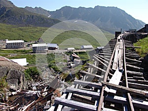
Mills, adits, sky-trams, and other extensive early-1900's mine workings throughout the area of the pass record the activity that brought the road in. Now only a handful of people live and work in Independence Bowl, and none in the surrounding valleys.
There are no known historical native settlements in the area, although Dena'ina Indians hunted for caribou, sheep, and moose in the western Talkeetna Mountains until the 1930s. Human development in the area, including the road over the pass, is almost entirely due to gold mining.
Almost all the land around the pass is public; there are numerous widely distributed small private land holdings, mainly mineral estates. The area is popular for daytrip recreation; sledding, skiing, snowmobiling, hiking, camping, hunting, white-water kayaking, berry-picking, climbing, recreational gold-mining, mountain biking, etc. Independence Mine State Historical Park consists of 271 acres (1.10 km2), with well-preserved mine buildings, and a mining museum which offers underground mine tours, in Independence Valley, an alpine valley just below the pass.[2][3] A large tract of land organized as the Hatcher Pass State Management area includes and surrounds the State Park and the pass.
Food and lodging is available at The Hatcher Pass Lodge in Independence Valley, and at the Motherlode Lodge at the foot of the pass on the Palmer side. In the 1970s the Independence Mine managers house (the current museum) was open as a bar and lodge.
Hatcher Pass is in the Willow Creek mining district. Over 500,000 ounces (14,000,000 g) of gold has been produced from the district.[8] The first mining claims were staked in the Hatcher Pass area in 1906. Underground hard-rock mining of gold from quartz veins accounts for most of the mineral wealth extracted from the Hatcher Pass area, although the first mining efforts were placer mining of stream gravels, and placer mining in the area has continued sporadically to this day. The first mill in the area started operating in 1908. Underground mining continued at a variety of locations around the pass until 1951. In the 1980s, one of the area's hard-rock mines was briefly re-opened. At least one mining company is actively exploring for gold in the area now.
Independence Mine, Alaska
Willow Creek placer gold was first discovered in 1896. In 1906, Robert Lee Hatcher staked the first hard rock claim in Hatcher Pass that would become Independence Mine. In the ensuing years, several mining operations began.
In 1938, the Alaska Free Gold Mine merged with Independence Mine to form the Alaska-Pacific Consolidated Minning Company (APC).
� Robert M. Braley Jr. | Dreamstime.com
In 1941, with 83 mining claims, the APC was the largest producer in the mining district, employing over 200 workers, opening nearly a dozen miles of tunnels, and producing over 34,000 ounces of gold. After World War II, mining in the district declined until the mine finally closed in 1951.
GOLD! A magic word that time cannot tarnish; a soft metal with the strength to forge history. Gold was the magnet that drew thousands of adventurers to the last frontier. Though most Alaskans recognize that gold played an important part in Alaska's history, they normally think first of Nome, Fairbanks, or the Iditarod country. But even before a quarter-of-a-million gold seekers began their stampede into those famous areas, gold was discovered just southeast of Anchorage in 1886. From there prospectors spread into the Susitna and Matanuska river basins, testing the creeks in the nearby mountains.
They found hard rock (lode) gold scattered in quartz veins throughout the granite in the Talkeetna Mountains. These veins were created by hydrothermal action that filled fractures in the rock. Erosion loosened flakes of gold, and flowing water eventually washed the gold-bearing gravel into a stream. Throughout the history of gold mining, placer mining has preceded lode mining, and this area was no exception. The rough-textured gold found in the bottom of pans and sluice boxes hinted at something more: a nearby source, or mother lode.
Robert Lee Hatcher discovered and staked the first lode gold claim in the Willow Creek Valley in September 1906, and others soon followed. But lode mining was expensive for an individual operator; it required elaborate tunnels and heavy equipment, so companies merged to pool resources and reduce expenses.
What is now called Independence Mine was once two mines: The Alaska Free Gold (Martin) Mine on Skyscraper Mountain, and Independence Mine on Granite Mountain. In 1938 the two were bought together under one company, the Alaska-Pacific Consolidated Mining Company (APC). With a block of 83 mining claims, APC became the largest producer in the Willow Creek Mining District. The claims covered more than 1,350 acres and included 27 structures. In its peak year, 1941, APC employed 204 men, blasted nearly a dozen miles of tunnels, and produced 34,416 ounces of gold worth $1,204,560; today $17,208,000. Twenty-two families lived in nearby Boomtown, with eight children attending the Territorial School in the new bunkhouse.
By 1942, the United States had entered World War II, and the War Production Board designated gold mining as nonessential to the war effort. Gold mining throughout the United States came to a halt, but Independence Mine continued to operate because of the presence of sheelite. Sheelite occurs in some of the quartz veins along with gold, and was a source of tungsten, a strategic metal. But because Independence Mine's scheelite production was low, the exemption was short-lived. In 1943, Independence Mine was ordered to close.
The wartime ban was lifted in 1946, but gold mining was slow to recover. After the war, gold could be sold only to the U.S. government at a fixed rate of $35 per ounce. Postwar inflation raged, and gold mining became an unprofitable venture. Finally, in January of 1951, after mining nearly 6 million dollars' worth of gold, Independence Mine was closed by APC, and a chapter of Alaska's gold mining history came to an end. In 1974, Independence Mine was entered into the National Register of Historic Places, a list of cultural resources significant to American history. In the late 1970's, 271 acres of land were donated to the Alaska Division of Parks & Outdoor Recreation for establishment of Independence Mine State Historical Park. On January 16, 1980, title to the acreage was transferred to the State of Alaska.
Advertisment Links to Dreamstime My RF Stock Agent Profile